Home
How Far Is Austin TX to San Antonio TX and What Are the Top Ways to Get There?
The journey between Austin and San Antonio is one of the most traveled corridors in the Southern United States. Whether you are a commuter heading to a business meeting, a tourist exploring the Alamo City, or a student moving between these two academic hubs, understanding the logistics of this 80-mile stretch is essential. While the physical distance remains constant, the time it takes to traverse this path can vary wildly based on the time of day, the route you choose, and the mode of transport you select.
In this guide, we will break down the exact mileage, analyze the traffic patterns of the notorious Interstate 35, and explore alternative routes like the SH-130 toll road. We will also compare public transit options, including bus and rail, to help you make an informed decision for your next Texas road trip.
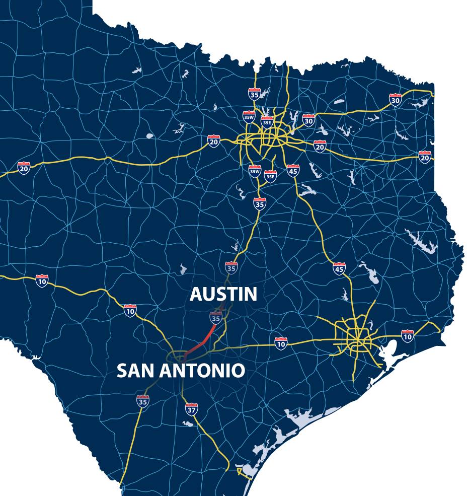
Image source: Texas Movers - Ward North American
How Many Miles Is It From Austin to San Antonio?
When calculating the distance between Austin and San Antonio, the answer depends largely on your starting and ending points. According to data from Travelmath , the straight-line distance—often referred to as "as the crow flies"—is approximately 73 to 74 miles (117 to 119 kilometers). However, unless you are traveling by private aircraft, the driving distance is the more relevant metric.
City Center to City Center
If you are driving from downtown Austin (near the Texas State Capitol) to downtown San Antonio (near the River Walk), the distance is typically cited between 77.4 and 81 miles . This variation accounts for different exit strategies and specific lane choices within the city centers. For international travelers, this equates to roughly 125 to 130 kilometers.
Suburban Variations
The "Austin area" is expansive. If you are starting in North Austin or a suburb like Round Rock, you should add approximately 15 to 20 miles to your total. Conversely, if you are leaving from South Austin (near Onion Creek), your journey to the northern outskirts of San Antonio could be as short as 65 miles. It is always wise to check your specific GPS coordinates, as a 15-mile difference in Texas can translate to an extra 30 minutes of travel time during peak hours.
How Long Does the Drive Actually Take?
In a perfect world, a 79-mile drive at 70 mph would take just over an hour. In Central Texas, however, "perfect" conditions are rare. The drive time between these two cities is famously unpredictable due to the heavy congestion on I-35.
The Best-Case Scenario
If you are traveling between 10:00 PM and 6:00 AM, or perhaps on a quiet Sunday morning, you can expect to make the trip in about 1 hour and 15 minutes . During these windows, the road is relatively clear, allowing you to maintain the posted speed limits of 65 to 75 mph throughout the journey.
The Reality of I-35 Traffic
During peak commuting hours, the drive time can easily double or even triple. Data from Texas Shuttle suggests that a Friday afternoon departure (between 3:30 PM and 6:30 PM) can result in a travel time of 2.5 to 3 hours . The congestion typically bottlenecks in three specific areas:
- Downtown Austin: The "upper and lower decks" of I-35 are a frequent source of delays.
- San Marcos: As a major university town and shopping destination, this area sees heavy merging traffic.
- Selma/Live Oak: The northern entrance to San Antonio often slows to a crawl as multiple highways converge.
Should You Take I-35 or the SH-130 Toll Road?
For many travelers, the choice between the "free" Interstate 35 and the "paid" SH-130 (also known as the Pickle Parkway) is a matter of time versus money. Each route offers a distinct experience.
The I-35 Experience
Free Route I-35 is the direct path. It takes you through the heart of the corridor's towns, providing easy access to gas stations, restaurants, and the famous San Marcos Premium Outlets. However, it is also the primary route for long-haul trucking, which contributes to the stop-and-go nature of the traffic.
The SH-130 Alternative
Toll Route SH-130 is a bypass that loops to the east of Austin and San Marcos. While it adds about 10 miles to the total distance, it features the highest speed limit in the United States at 85 mph . During a heavy traffic event on I-35, taking SH-130 can save you 45 minutes or more.
Cost-Benefit Analysis
The toll for a passenger vehicle traveling the full length from Austin to San Antonio ranges from $7 to $13 , depending on whether you have a TxTag or are being billed by mail. If you value your time at more than $15 per hour, the toll road ranks among the top choices for weekday travel. During a Friday 5:00 PM rush, the "price per minute saved" on SH-130 is often less than 25 cents—a bargain for many commuters.
Image source: Coventry Homes
Comparing Bus, Train, and Rideshare Options
If you prefer not to drive, several alternatives exist. Each has its own set of pros and cons regarding cost, comfort, and reliability.
| Mode | Avg. Cost | Duration | Best For |
|---|---|---|---|
| Personal Car | $25 - $35 (Gas/Tolls) | 1.5 - 2.5 Hours | Flexibility & Groups |
| FlixBus / Greyhound | $15 - $30 | 1.75 - 2.5 Hours | Budget Travelers |
| Amtrak (Texas Eagle) | $10 - $25 | 3 - 3.5 Hours | Leisure & Comfort |
| Uber / Lyft | $90 - $150 | 1.5 - 2 Hours | Door-to-Door Ease |
The Truth About Bus Travel Times
When booking a bus, you may see claims of very short travel times. For instance, some data points from FlixBus have occasionally suggested trips as short as 35 minutes. It is important to debunk this: given the 80-mile distance, a 35-minute trip would require an average speed of 137 mph. In reality, you should plan for 1.5 to 2.5 hours for any bus journey, accounting for boarding and potential traffic delays.
Amtrak Texas Eagle
The Amtrak Texas Eagle offers a scenic and relaxing way to travel between the two cities. The train features wide seats, power outlets, and a viewing car. However, it is not a high-speed rail. The journey typically takes over 3 hours, and the train is subject to delays as it shares tracks with freight lines. It is an excellent choice for those who want to work or relax, but not for those on a tight schedule.
Rideshare Economics
According to Uber , the average cost for a one-way trip is approximately $109 . This can fluctuate based on demand. For a solo traveler, this is expensive, but for a group of four, it becomes a highly competitive alternative to taking multiple bus tickets, especially considering the door-to-door convenience.
Top Places to Stop Along the I-35 Corridor
The drive doesn't have to be a grueling slog. There are several iconic Texas landmarks along the way that can turn a commute into a mini-adventure.
Buc-ee's (New Braunfels)
Widely considered a mandatory stop, this location is one of the largest convenience stores in the world. It features dozens of gas pumps, pristine restrooms, and their famous "Beaver Nuggets."
San Marcos Outlets
A massive shopping destination featuring two distinct malls. It is a top choice for those looking for designer brands at a discount, located right at the halfway point.
Gruene Hall
A short detour into New Braunfels takes you to Texas' oldest continually operating dance hall. It is a significant historical site and a great place for a quick photo or a cold drink.
Family and Pet Sanity Stops
If you are traveling with children or pets, specific exits offer much-needed relief:
- Mile 206 (San Marcos River): Rio Vista Park offers a chance to dip your feet in the water and let the kids run around.
- Mile 174 (New Braunfels): Landa Park is a beautiful green space with a miniature train and plenty of shade for pets.
Understanding the Geology of the Balcones Fault Line
One reason the drive between Austin and San Antonio is so unique is that I-35 was constructed almost exactly along the Balcones Fault line . This geological feature marks the boundary between two very different Texas landscapes.
To the east of the highway lies the Blackland Prairie—flat, fertile farmland that stretches toward the coast. To the west, the land rises into the Texas Hill Country, characterized by limestone cliffs, rolling hills, and deep caverns. This fault line is the reason you see so many rock cuts along the highway and why the area is prone to "flash flood alley" weather patterns. The elevation change also creates the natural springs that feed the rivers in San Marcos and New Braunfels, which have been vital to human settlement in this corridor for thousands of years.
What to Do if You Get Stranded or Miss Your Last Bus
Travel plans don't always go as expected. If you find yourself in Austin late at night without a ride back to San Antonio, follow the "Stuck in Austin" protocol to ensure your safety and comfort.
- Check the Eastside Bus Plaza: Most intercity buses depart from the Austin Eastside Bus Plaza. Check their latest schedule online, as late-night "standby" seats occasionally become available.
- Use Uber Reserve: If you know you will need a late-night ride, you can use the Uber "Reserve" feature up to 90 days in advance. This provides a higher level of certainty than trying to hail a car at 2:00 AM.
- Find a 24-Hour Haven: If you have several hours to wait, head to a 24-hour diner. Magnolia Cafe or Kerbey Lane Cafe are local staples that offer a safe, well-lit environment and hot coffee while you wait for the first morning bus or train.
- Consider the Airport Shuttle: Even if you aren't flying, shuttles running between Austin-Bergstrom (AUS) and San Antonio (SAT) often run later than standard city-to-city buses.
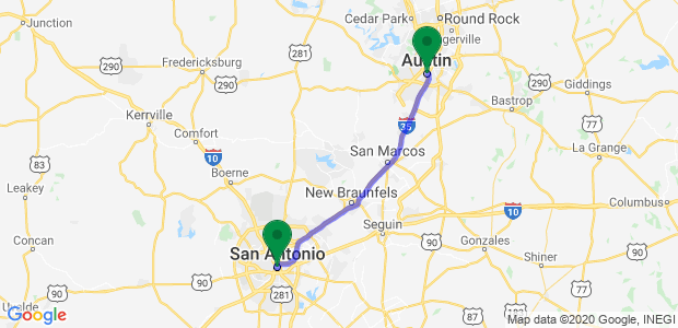
Image source: Move Advisor
Frequently Asked Questions
- Is there a high-speed rail between Austin and San Antonio?
- Currently, there is no high-speed rail service. While there have been numerous proposals for a "Lone Star Rail" or a private high-speed line similar to the one proposed for Dallas-Houston, these projects are still in the planning or legislative phases. For now, Amtrak is the only rail option.
- What is the cheapest way to get from Austin to San Antonio?
- The most budget-friendly option is typically a bus service like FlixBus or Megabus. If you book at least 48 hours in advance, you can often find one-way tickets for as low as $15. Prices tend to rise significantly for last-minute bookings or weekend travel.
- How much is an Uber from Austin to San Antonio?
- On average, you can expect to pay around $109 for a standard UberX. However, during periods of high demand (such as during SXSW in Austin or Fiesta in San Antonio), surge pricing can push this cost well over $200.
- Is the drive from Austin to San Antonio scenic?
- The I-35 route is largely industrial and commercial, consisting of billboards, gas stations, and shopping centers. For a more scenic experience, consider taking the "backroads" through Wimberley and Blanco (Highway 12 to Highway 281). This adds about 30-40 minutes but offers beautiful Hill Country views.
- What is the best time to leave Austin to avoid San Antonio traffic?
- To avoid the worst of the congestion, aim to be past the San Marcos outlets by 3:00 PM or wait until after 7:00 PM. If you are heading into San Antonio for a morning meeting, leaving Austin by 6:15 AM is usually necessary to beat the Selma bottleneck.
The Bottom Line on Traveling Between Austin and San Antonio
Navigating the 80-mile gap between these two Texas powerhouses requires a mix of timing, route selection, and patience. Here are the key takeaways for your journey:
- Distance Matters: Plan for a 77-81 mile trip, but remember that starting in North Austin can add significant mileage.
- Timing is Everything: Avoid the I-35 corridor during the 7-9 AM and 3:30-6:30 PM rush hour windows to prevent a 3-hour ordeal.
- Tolls Save Time: The SH-130 bypass is a top-tier option during peak traffic, offering an 85 mph speed limit for a modest fee.
- Verify Bus Times: Don't rely on "35-minute" bus claims; a realistic transit time is closer to 2 hours.
- Make it a Trip: Utilize stops like Buc-ee's or the San Marcos River to break up the monotony of the drive.
- Geological Context: The route follows the Balcones Fault, creating a unique transition from prairie to hill country.
- Have a Backup: If you miss the last bus, use rideshare reservation features or wait in a 24-hour diner for the next morning's departure.
Before you head out, check a real-time traffic app to see if I-35 is clear or if the SH-130 bypass is your most efficient path forward.