Home
How Big Is Texas Compared to Other States and Countries?
The phrase "everything is bigger in Texas" is more than just a local boast; it is a geographic reality that shapes the state's culture, economy, and infrastructure. Spanning nearly 800 miles from north to south and east to west, the Lone Star State represents a massive portion of the American landscape. Whether you are measuring by square mileage, highway distance, or economic output, the scale of Texas is difficult to grasp without direct comparisons.
Understanding how big Texas really is requires looking beyond the raw numbers. While the figure of 268,597 square miles is impressive, it is the functional scale—how long it takes to drive across it, how many countries could fit inside it, and how its infrastructure wraps around the globe—that truly defines its vastness. In this guide, we explore the physical and economic dimensions of Texas to provide a clear picture of its place on the global map.
Just How Many Square Miles Is the Lone Star State?
When discussing the size of Texas, it is important to distinguish between total area and land area. According to Wikipedia's data on Texas , the state encompasses 268,597 square miles. However, this total includes 7,365 square miles of water, accounting for roughly 2.7% of the state's surface. The remaining 261,232 square miles consist of diverse landmasses ranging from coastal plains to high deserts.
This massive footprint secures Texas's position as the second-largest state in the Union. It trails only Alaska in terms of total area, but it significantly outpaces California, the third-largest state, by over 100,000 square miles. For context, the difference in size between Texas and California is roughly equivalent to the entire land area of Colorado.
The Population Density Factor
Despite its enormous size, Texas is not as crowded as one might expect. As of recent 2026 estimates, the population has grown to approximately 31.7 million residents. While this makes it the second most populous state, its vast land area results in a population density of about 111 people per square mile. This is a stark contrast to states like New Jersey, which has over 1,200 people per square mile, or the dense urban corridors of the Northeast.
This openness is a defining characteristic of the Texas experience. The state's size allows for massive metropolitan hubs like Houston, Dallas, and Austin to exist alongside millions of acres of ranch land, state parks, and uninhabited wilderness. This balance of urban development and rural expanse is only possible because of the sheer volume of available land.
How Texas Compares to the Rest of the United States
Visualizing the scale of Texas often involves comparing it to other U.S. states. One of the most common ways to illustrate this is the "11 States" visual. If you were to take the landmasses of Maine, New Hampshire, Vermont, Massachusetts, Rhode Island, Connecticut, New York, Pennsylvania, Ohio, and North Carolina, you could fit all of them inside the borders of Texas with room to spare. This highlights how the Northeastern U.S., which contains dozens of major cities and millions of people, represents only a fraction of the space available in the Lone Star State.
While Texans take pride in their size, Alaska remains the undisputed heavyweight of U.S. geography. Alaska is approximately 2.5 times larger than Texas. However, a significant portion of Alaska is uninhabitable or inaccessible due to extreme terrain and climate. Texas, by contrast, has a much higher percentage of "usable" land for agriculture, industry, and residential development.
Another interesting metric is coastline. Despite its massive size, Texas has a relatively short coastline of 367 miles along the Gulf of Mexico. When compared to Alaska’s 6,640 miles of coastline, it becomes clear that "big" does not always translate to "long coast." However, the Texas coast is home to some of the busiest ports in the world, proving that the state makes the most of every mile it has.
| State | Total Area (Sq Mi) | Population (Approx. 2026) | Coastline (Miles) |
|---|---|---|---|
| Alaska | 665,384 | 733,000 | 6,640 |
| Texas | 268,597 | 31,700,000 | 367 |
| California | 163,696 | 39,200,000 | 840 |
| Rhode Island | 1,545 | 1,090,000 | 40 |
Putting Texas on the Global Map
On a global scale, Texas is larger than many well-known sovereign nations. If Texas were its own country, it would be the 40th largest in the world, ranking just behind Zambia and ahead of Myanmar. For those familiar with European geography, the comparisons are even more striking. Texas is roughly 1.2 times larger than France, nearly twice the size of Germany, and almost three times the size of the United Kingdom.
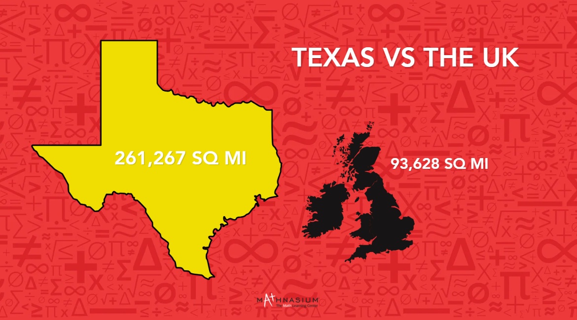
Image source: Mathnasium
The "Mercator Distortion" often makes Texas look smaller on standard world maps than it actually is. Because the Mercator projection stretches landmasses near the poles, countries like Greenland or Sweden appear much larger than they are, while regions near the equator—like Texas—appear smaller. When you correct for this distortion, you can see that Texas could easily cover the combined areas of France, Belgium, and the Netherlands.
According to MyLifeElsewhere's size comparison tools , the sheer landmass of Texas allows it to host a variety of ecosystems that would normally be spread across multiple countries. From the lush forests of the east to the arid deserts of the west, the state functions like a small continent in terms of geographic diversity.
The Mind-Boggling Scale of Texas Infrastructure
Maintaining a state this large requires an infrastructure network that is exceptionally strong. The Texas Department of Transportation (TxDOT) manages over 313,000 lane miles of highway. To put that in perspective, if you were to lay those highway lanes end-to-end, they would be long enough to circle the Earth’s equator 12 times. This is a top-tier engineering feat that few other regions in the world can match.
The scale of this network is a necessity, not a luxury. Because the major population centers of Houston, Dallas, San Antonio, and Austin are hundreds of miles apart, the state relies on a robust transit system to move goods and people. This infrastructure is the backbone of the Texas economy, facilitating the movement of energy, agricultural products, and technology across vast distances.
"The sheer volume of asphalt and concrete required to connect Texas cities is a testament to the state's geographic ambition. We aren't just building roads; we are building a functional web across a landmass larger than most nations."
Furthermore, the state's size has led to the development of some of the most complex interchanges and highway systems in the world. The "High Five" interchange in Dallas, for example, stands as tall as a 12-story building, reflecting the vertical and horizontal scale required to manage Texas-sized traffic volumes.
Why Driving Across Texas Takes So Long
Anyone who has attempted a road trip across Texas can attest to the "internal distance paradox." Because the state is so wide, you can drive for 10 to 12 hours at highway speeds and never cross the state line. The most famous example of this is the drive from El Paso to Orange, Texas. This journey covers approximately 870 miles along Interstate 10.
To understand how strange this distance is, consider that El Paso is geographically closer to San Diego, California (720 miles) than it is to Houston, Texas (740 miles). When you are in the far western tip of Texas, you are closer to the Pacific Ocean than you are to the Gulf of Mexico. Similarly, driving from El Paso to the northern border of the Texas Panhandle is roughly the same distance as driving from El Paso to Denver, Colorado.
Most travelers entering Texas from the east at the Louisiana border and heading west toward New Mexico will spend at least 11 to 13 hours on the road. This "marathon drive" is a rite of passage for many Americans and serves as a visceral reminder of the state's immense proportions.
This vastness also impacts how Texans perceive distance. In many parts of the country, a two-hour drive is considered a major trip. In Texas, a two-hour drive is often just a commute or a quick trip to the next town over. The state's size has fostered a unique driving culture where high speed limits (up to 85 mph in some areas) and long-distance travel are the norms.
The Economic Size of Texas Might Surprise You
Size isn't just about dirt and roads; it's also about economic footprint. If Texas were an independent nation, its economy would rank among the top in the world, rivaling countries like Brazil, Canada, and South Korea. The state's Gross State Product (GSP) is a significant driver of the U.S. national economy, particularly in the energy, aerospace, and technology sectors.
The Dallas-Fort Worth (DFW) metro area provides a perfect example of this economic scale. According to economic data discussed in regional forums , if the DFW metro area were its own country, its GDP would rank 24th globally. This means a single metropolitan area in Texas has a larger economy than many entire nations, including Sweden and Saudi Arabia.
This economic "size" allows Texas to exert significant influence on global markets. As a leader in oil and gas production, wind energy, and semiconductor manufacturing, the state's industrial output is as massive as its physical borders. The scale of the Texas economy provides a level of stability and growth that makes it a top choice for corporate relocations and international investment.
What Would Happen if Texas Was as Dense as New York City?
A fascinating way to visualize the size of Texas is through a density thought experiment. Currently, the world's population is approximately 8 billion people. If you were to take the entire population of the Earth and place them within the borders of Texas, how crowded would it be? The answer depends entirely on the density of the population.
According to calculations by Mathnasium , if Texas were as densely populated as New York City, it could hold roughly 7 billion people. This means that nearly the entire global population could fit inside the Lone Star State if we lived in high-rise apartments and used public transit like New Yorkers. This highlights just how much "empty" space currently exists in Texas.
In reality, Texas is nowhere near that density. With only 31.7 million people, the state feels vast and open. This low density is one of the reasons why land remains relatively affordable compared to the coastal U.S., and why the "ranch lifestyle" remains a viable part of the state's identity. The state isn't just big; it is sparsely populated enough to offer a sense of freedom that is harder to find in smaller, more crowded states.
How Size Creates Four Different Climates in One State
The 800-mile span of Texas means that the state does not have a single "Texas climate." Instead, its size allows it to encompass four distinct ecological and climatic zones. This diversity is a direct result of the state's latitudinal and longitudinal reach.
- The Piney Woods (East Texas): This region is characterized by high rainfall, humidity, and dense forests of pine and hardwood. It feels more like Louisiana or Mississippi than the stereotypical Texas desert.
- The Gulf Coastal Plain: Stretching along the coast, this area is subtropical and prone to hurricanes. It features marshes, barrier islands, and fertile prairies.
- The Great Plains (The Panhandle): This high-altitude region is flat, windy, and subject to extreme temperature swings. It experiences snow in the winter and intense heat in the summer.
- The Basin and Range (West Texas): This is the classic "Old West" landscape, featuring the Chihuahuan Desert and the only mountains in the state, including the Guadalupe Mountains.
This climatic variety means that on any given day, it could be snowing in Amarillo while people are sunbathing on the beaches of South Padre Island. The state's size creates a geographic buffer that allows these vastly different environments to coexist within a single political border.
Frequently Asked Questions
Is Texas bigger than the UK?
Yes, Texas is significantly larger than the United Kingdom. Texas covers approximately 268,597 square miles, while the UK covers about 94,000 square miles. This makes Texas nearly three times the size of the UK. You could fit the UK into Texas twice and still have plenty of room for several smaller European countries.
How many states can fit in Texas?
Depending on the combination, you can fit between 11 and 15 U.S. states inside Texas. A common comparison includes the entire Northeastern U.S. (Maine, NH, VT, MA, RI, CT, NY, PA, NJ, DE, and MD). All of these states combined still have less total land area than the Lone Star State.
Is Texas bigger than France?
Yes, Texas is larger than France. France, the largest country in the European Union by land area, covers about 213,000 square miles. Texas, at 268,597 square miles, is approximately 1.2 times larger than France. If Texas were a country in Europe, it would be the largest on the continent excluding Russia.
How long does it take to drive across Texas?
Driving across Texas from east to west (Orange to El Paso) takes roughly 12 to 14 hours of actual driving time, covering about 870 miles. Driving from north to south (Dalhart to Brownsville) takes a similar amount of time, approximately 13 hours for the 900-mile journey. These times can vary significantly based on traffic in major cities like Houston or Austin.
Is Texas the largest state in the US?
No, Texas is the second-largest state in the U.S. Alaska is the largest, with a total area of about 665,384 square miles, making it roughly 2.5 times the size of Texas. However, Texas is the largest state in the "Lower 48" or contiguous United States.
The Bottom Line on Texas Size
Texas is a geographic titan that defines the scale of the American South and West. Its massive footprint influences everything from national politics to global energy markets. Here are the key takeaways regarding its size:
- Total Area: Texas covers 268,597 square miles, making it the 2nd largest U.S. state.
- Global Standing: It is larger than major European nations, including France, Germany, and the UK.
- Infrastructure: The state's 313,000+ lane miles of highway could wrap around the Earth's equator 12 times.
- Economic Power: The DFW metro area alone has a GDP that would rank 24th globally if it were a country.
- Driving Distance: The 870-mile trek from El Paso to Orange is one of the longest intra-state drives in the nation.
- Population Density: Despite its 31.7 million residents, the state remains relatively open with 111 people per square mile.
- Climatic Diversity: Its size allows for four distinct climate zones, from humid forests to arid deserts.
Next time you look at a map, remember that the scale of Texas is a significant factor in its identity, proving that in this case, the legend of its size is backed by undeniable data.