Home
Tri-State Area Braces for Significant Snow and Blizzard Conditions from Developing Nor’easter
A powerful Nor’easter is expected to impact the Tri-State area starting Sunday evening, February 22, 2026 , and lasting through Monday morning, February 23 . Meteorologists warn of a "bomb cyclone" effect, potentially dropping 12–18 inches of snow in New York City and North Jersey. Blizzard conditions, including hurricane-force wind gusts and visibility under a quarter-mile, are highly likely along the I-95 corridor. Commuters should prepare for significant transit suspensions on NJ Transit, LIRR, and Metro-North.
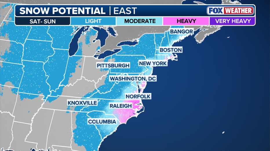
Image source: FOX 5 New York
When Will the Snow Start and How Long Will It Last
The progression of this storm follows a classic Nor’easter pattern, but its rapid intensification makes the timing window particularly narrow for residents. According to FOX 5 NY , the storm will begin its primary impact late Sunday, following a deceptively mild Saturday.
Expect a high of 46°F with mostly cloudy skies. This is the final 24-hour window to clear gutters, secure outdoor furniture, and ensure generators are fueled. The mild temperatures will drop sharply after sunset.
Precipitation begins. In coastal areas, this may start as a cold rain or slushy mix before rapidly transitioning to heavy snow as the "bomb cyclone" begins to pull Arctic air into the system's center.
The peak of the storm. Expect snowfall rates of 1–3 inches per hour. This coincides with the morning commute, creating high-risk travel conditions across all major highways and rail lines.
Snow begins to taper off from south to north, but high winds will continue to cause blowing and drifting snow, keeping roads hazardous well into the evening.
Meteorologists emphasize that the transition period on Sunday night is critical. As temperatures hover near the 32°F mark, the density of the snow will shift. Initial snowfall may be wet and heavy, increasing the risk of immediate power outages before the air turns cold enough for lighter, wind-driven snow that creates blizzard conditions.
How Much Snow Will You Actually Get
Snow totals for this event are highly dependent on the storm's exact track. A shift of just 50 miles can be the difference between a historic blizzard and a minor slushy event. Current projections from NBC New York suggest that the I-95 corridor remains the "bullseye" for the heaviest accumulation.
For New York City and North Jersey, the consensus among major models points toward a range of 12 to 18 inches. However, areas further inland, such as the Ohio Valley, may see lower totals of 3 to 6 inches as the storm gains its primary strength only after reaching the Atlantic moisture. Conversely, parts of New England and Boston could see totals exceeding 12 inches as the storm tracks northeast.
Projected Snow Totals by Sub-Region
| Region | Expected Accumulation | Primary Hazard |
|---|---|---|
| NYC / Manhattan | 12–18 Inches | Blizzard Conditions / Transit Stops |
| North Jersey (Bergen/Passaic) | 14–20 Inches | Heavy Wet Snow / Power Outages |
| Long Island (Suffolk) | 3–12 Inches (Variable) | Coastal Flooding / High Winds |
| Coastal Connecticut | 10–15 Inches | Hurricane-Force Gusts |
| Central NJ (Trenton/Edison) | 6–10 Inches | Ice Accretion / Slippery Roads |
The "wild card" in this forecast remains the Jersey Shore and Long Island. If the storm tracks closer to the coast, these areas will see a significant "warm nose" of air off the ocean, turning snow into rain and drastically reducing totals. If the storm stays further offshore, these regions could easily see over a foot of snow.
Why the Weather Models Are Fighting Over This Storm
Forecasting a Nor’easter involves balancing multiple complex variables, leading to what meteorologists call a "model war." The two primary contenders for this storm are the Global Forecast System (GFS) and the Baron model. Understanding their differences is key to interpreting the shifting forecasts.
The GFS Model
Stance: Aggressive / Direct Hit
The GFS predicts the storm will track closer to the coast, tapping into the maximum temperature contrast between Arctic air and the warm Gulf Stream. This scenario results in 16+ inches for NYC and widespread blizzard conditions.
The Baron Model
Stance: Conservative / Outlier
The Baron model currently suggests the storm will stay further offshore. In this scenario, the heaviest bands of snow miss the Tri-State, resulting in a "near miss" with only 2–5 inches of accumulation for the city.
The "50-Mile Jog" rule is a standard in Tri-State meteorology. Because the region sits on the edge of the rain-snow line, a minor shift in the storm's center—less than the distance of a standard commute—changes the entire outcome. Residents should monitor Saturday night updates closely, as this is when the models typically converge on a final solution.
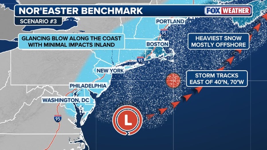
Image source: FOX 5 New York
The Science Behind the Bomb Cyclone and Rapid Intensification
This storm is not a typical winter low-pressure system; it is expected to undergo bombogenesis . According to FOX Weather , a "bomb cyclone" occurs when a storm's central pressure drops by at least 24 millibars within a 24-hour period.
This rapid intensification is fueled by the extreme temperature gradient between the freezing Arctic air mass moving over the continent and the relatively warm waters of the Atlantic Ocean. As the pressure plummets, the wind field expands and intensifies. This storm is projected to produce hurricane-force wind gusts exceeding 74 mph, particularly along the coast and in high-rise areas of Manhattan.
The physical impact of such a pressure drop is significant. It creates a "vacuum effect" that pulls moisture from the ocean and converts it into intense snowfall rates. Even if the storm track shifts and snow totals decrease, the wind energy alone makes this a high-impact event capable of structural damage and coastal erosion.
How to Prepare for Power Outages and Heavy Wet Snow
One of the most dangerous aspects of this Nor’easter is the "sneaky warm layer." As identified by winter storm specialists, a layer of air above freezing can become trapped between two freezing layers. This does not always result in rain; instead, it often creates ice pellets or freezing rain.
Even a small amount of ice accretion—between 0.10 and 0.25 inches—is enough to snap power lines and tree limbs, especially when combined with high winds. Furthermore, the snow itself is expected to be "heavy and wet" rather than the light, fluffy "powder" seen in mid-winter storms. This type of snow is significantly denser, weighing down roofs and making manual clearing much more physically taxing.
Storm Readiness Checklist
Safety experts at Weather.gov advise against overexertion while shoveling heavy wet snow. The physical strain on the heart is significantly higher during these conditions. If you have a history of heart conditions, it is highly recommended to seek assistance or wait for the snow to melt if possible.
What Commuters Need to Know About NJ Transit LIRR and Metro-North
The Monday morning commute is expected to be a total collapse of regional transit. The combination of heavy wet snow and hurricane-force gusts creates a "perfect storm" for rail infrastructure. Commuters should monitor the following failure points:
- Catenary Wire Vulnerability: NJ Transit and Metro-North rely on overhead wires that are highly susceptible to sagging and snapping under the weight of wet snow and ice.
- The "Frozen Point" Problem: Rail switches (points) can freeze despite internal heaters when temperatures drop rapidly alongside heavy precipitation. This leads to system-wide delays as trains cannot be diverted.
- Third Rail Icing: The Long Island Rail Road (LIRR) often struggles with ice buildup on the third rail, which prevents trains from drawing power.
State officials, including Governor Hochul, have already begun discussing potential State of Emergency declarations. These declarations often include travel bans for commercial vehicles on the New York State Thruway and I-95, which can eventually extend to passenger vehicles if blizzard conditions persist. According to Newsweek , residents should expect "System-Wide Suspensions" to be announced as early as Sunday night.
Key Takeaways for Storm Safety
- Timing is Critical: The window for safe travel closes Sunday evening. Plan to be at your final destination by 6:00 PM Sunday.
- Expect Power Outages: The combination of heavy wet snow and hurricane-force gusts makes widespread outages likely in North Jersey and Westchester.
- Monitor the "Jog": Watch for Saturday night updates; if the storm shifts 50 miles east, NYC totals will drop significantly.
- Commuter Alert: Monday morning travel is strongly discouraged. Check transit apps for "System-Wide Suspensions" before heading to stations.
- Safety First: Do not shovel heavy wet snow if you have a history of heart conditions; the physical strain is significantly higher than with dry snow.
- Carbon Monoxide Risk: Ensure all heating vents are clear of snow drifts to prevent deadly gas buildup inside the home.
Stay tuned to local weather radio and official emergency apps for real-time updates as the storm center approaches the coast.
Frequently Asked Questions
Snow is expected to begin as a mix Sunday evening, February 22, turning to heavy snow between 9:00 PM and midnight. The most intense period of the storm will occur during the early morning hours of Monday, coinciding with the peak commute time.
While not every Nor'easter is a blizzard, this storm has a high potential to meet the criteria. A blizzard requires sustained winds or frequent gusts of 35 mph or greater and considerable falling or blowing snow that reduces visibility to under a quarter-mile for at least three hours.
Nor'easters are specifically defined by their winds blowing from the northeast and their development along the East Coast. They are often more intense than standard inland snowstorms because they tap into the moisture and warmth of the Atlantic Ocean, frequently undergoing rapid intensification known as bombogenesis.
While school districts typically wait until the morning of the event to announce closures, the timing of this storm makes Monday closures highly likely across New York, New Jersey, and Connecticut. Parents should check local news outlets or district websites by Sunday evening.
The Baron model is a proprietary meteorological model that is currently acting as an outlier. While the GFS and NAM models predict a direct hit for NYC, the Baron model suggests the storm will track further east into the Atlantic, which would result in much lower snow totals for the Tri-State area.