Home
How Many Counties Are in Georgia and Why Are There So Many?
For residents and visitors alike, the sheer number of counties in Georgia often comes as a surprise. While the state ranks 24th in total land area, its administrative map is one of the most fragmented in the nation. This high count is not merely a historical accident; it is the result of a complex interplay between early transportation needs, strategic political engineering, and a rigid constitutional cap that has remained in place for over 80 years.
The Quick Answer for 2026
Georgia maintains a total of 159 counties , a number that has remained static since the early 20th century. To put this in perspective, Georgia has more counties than states like California, Florida, and New York, despite having a smaller landmass. According to historical records , Georgia ranks second in the U.S. for county count, with Texas leading the nation at 254 counties.
The stability of this number is legally mandated. The 1945 Georgia State Constitution established a formal cap, stating that no more than 159 counties can exist at any given time. This means that for a new county to be created, an existing one would have to be dissolved or merged—a process that is politically and logistically difficult. The last county to be successfully established was Peach County in 1924, just before the legal limits became more stringent.
Why Does Georgia Have So Many Counties?
There are two primary explanations for why Georgia’s map looks like a patchwork quilt. One is a charming piece of folklore, while the other is a calculated political strategy that shaped the state's power dynamics for decades.
The "Mule Ride" Myth
The most common explanation given to Georgia schoolchildren is the "mule ride" theory. The idea was that every resident should be able to travel from their home to the county seat, conduct their legal business (such as paying taxes or attending court), and return home within a single day by horse or mule. Given the slow pace of travel in the 18th and 19th centuries, this necessitated small county sizes, typically with a radius of about 20 miles. While this logic explains the physical size of the counties, it doesn't fully explain why Georgia has so many more than its neighbors with similar terrain.
The Political Reality: The County Unit System
Historians point to a more strategic reason: the County Unit System . Established formally in 1917, this system functioned similarly to a state-level Electoral College. It allocated votes to counties based on their classification as "urban," "town," or "rural." Small rural counties were given a disproportionate amount of power relative to their population. By creating more small counties, rural political leaders could effectively dilute the voting power of growing urban centers like Atlanta.
This system ensured that rural interests dominated state politics for the first half of the 20th century. It wasn't until the landmark Supreme Court case Baker v. Carr (1962) and subsequent rulings that the "one man, one vote" principle was enforced, ending the strategic advantage of maintaining numerous tiny counties. However, by that time, the 159-county map was already firmly established in the state constitution.
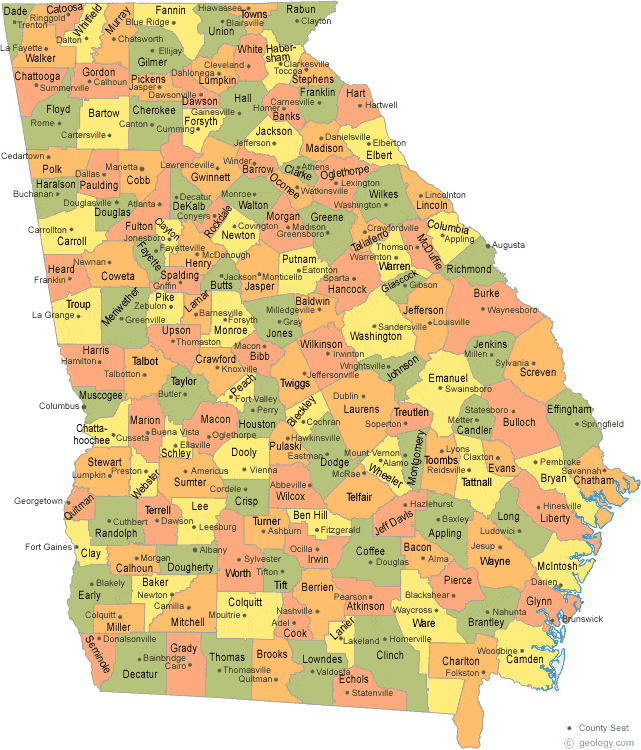
Image source: Geology.com
The Story of Georgia’s "Lost Counties"
While the number 159 is now fixed, Georgia actually used to have 161 counties. The story of the "lost counties" is a fascinating chapter in the state's economic history, particularly during the Great Depression.
- Milton County: Established in 1857, Milton County was located north of Atlanta. By the early 1930s, the county was facing total bankruptcy. In 1932, it was absorbed into Fulton County to ensure that residents continued to receive basic services and that schools remained open.
- Campbell County: Located southwest of Atlanta, Campbell County faced similar financial ruin during the Depression. It followed Milton's lead and merged with Fulton County in 1932.
Today, the area formerly known as Milton County is one of the wealthiest parts of the state, encompassing cities like Alpharetta and Milton. This has led to recurring modern political movements to "re-establish" Milton County and secede from Fulton. However, because of the 159-county constitutional cap, creating a new Milton County would require a statewide constitutional amendment or the dissolution of another existing county, making it a significant legal hurdle.
Understanding Unique County Governance in Georgia
In Georgia, the term "county" doesn't always refer to a standalone government. The state has pioneered several unique forms of local administration to handle the challenges of having so many small jurisdictions.
Consolidated City-County Governments
To improve efficiency, several Georgia counties have merged their city and county governments into a single entity. As of 2026, there are 8 such consolidated governments. These include:
- Athens-Clarke County
- Augusta-Richmond County
- Columbus-Muscogee County
- Macon-Bibb County
- Cusseta-Chattahoochee County
- Georgetown-Quitman County
- Statenville-Echols County
- Webster County
Because these entities function as a single government, the U.S. Census Bureau sometimes lists Georgia as having only 152 "functioning" county governments, even though the legal count remains 159.
The Sole Commissioner System
Georgia is notably the only state in the U.S. that still utilizes a "Sole Commissioner" system in some areas. In this system, a single elected official holds all executive and legislative power for the county. While most counties have moved to a Board of Commissioners, seven counties—including Bartow, Walker, and Union—still retain this vestige of early 20th-century governance. This system is often praised for its efficiency but criticized for its lack of checks and balances.
Georgia County Statistics and Rankings (2024-2026)
The diversity among Georgia's counties is staggering, ranging from massive urban hubs to tiny rural communities. Below is a snapshot of the extremes within the 159 counties based on recent data.
| Category | County | Statistic |
|---|---|---|
| Most Populous | Fulton County | 1.1M+ Residents |
| Least Populous | Taliaferro County | ~1,600 Residents |
| Largest by Land Area | Ware County | 908 sq. miles |
| Smallest by Land Area | Clarke County | 121 sq. miles |
| Fastest Growing (2026) | Houston County | Middle GA Innovation Corridor |
A significant trend in 2026 is the rise of the Middle Georgia Innovation Corridor . Counties like Houston and Baldwin are seeing substantial economic growth driven by the aerospace and agribusiness sectors. According to the Middle Georgia Innovation Corridor , these counties are becoming top choices for tech investment outside of the Atlanta metro area.
The SPLOST Factor: How Georgia Counties Fund Themselves
With so many counties, funding local infrastructure is a constant challenge. Georgia utilizes a unique mechanism called SPLOST (Special Purpose Local Option Sales Tax). This is a one-cent sales tax voted on by county residents to fund specific capital projects like roads, schools, and parks.
Interestingly, the reliance on SPLOST is nearly universal. Historically, only a handful of counties have operated without this tax. For residents, the SPLOST system means that local improvements are often funded by anyone shopping in the county, rather than relying solely on property taxes from homeowners. This is a critical component of how 159 separate jurisdictions manage to maintain their own independent school systems and road networks.
Complete List of Georgia Counties
Below is a selection of Georgia's 159 counties, including their county seats and the year they were established. This list highlights the rapid expansion of the state during the 1800s.
| County | County Seat | Year Established |
|---|---|---|
| Appling | Baxley | 1818 |
| Barrow | Winder | 1914 |
| Chatham | Savannah | 1777 |
| Fulton | Atlanta | 1853 |
| Gwinnett | Lawrenceville | 1818 |
| Peach | Fort Valley | 1924 |
| Ware | Waycross | 1824 |
For a full directory, researchers often consult Ballotpedia's Georgia County guide , which provides detailed governance and election data for all 159 jurisdictions.
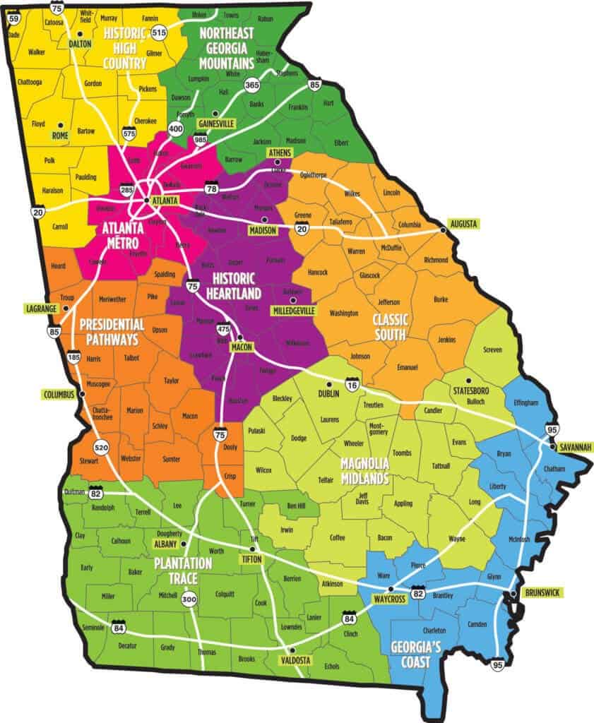
Image source: Spiva Law Group
Frequently Asked Questions
Why does Georgia have exactly 159 counties?
What is the largest county in Georgia by land area?
What was the last county formed in Georgia?
How many counties in Georgia have a sole commissioner?
Is there a Milton County in Georgia?
Key Takeaways
Understanding Georgia's 159 counties provides a window into the state's unique political and social history. Here are the essential points to remember:
- Total Count: Georgia has 159 counties, ranking second in the U.S. behind Texas.
- Legal Cap: The number is capped by the 1945 Constitution , making the creation of new counties extremely difficult.
- Historical Drivers: The high count was influenced by the "mule ride" travel radius and the County Unit System of voting.
- Lost Jurisdictions: Milton and Campbell counties were absorbed into Fulton County in 1932.
- Governance Nuance: The state features 8 consolidated governments and 7 counties that still use a Sole Commissioner system.
- Economic Growth: Modern growth is shifting toward the Middle Georgia Innovation Corridor , including Houston and Baldwin counties.
To explore the specific boundaries of your local area, you can view an interactive version of the Georgia County Map for precise geographic data.