Home
Interactive Florida County Map with Cities and Detailed Regional Data
Navigating the geography of the Sunshine State requires more than just a basic outline. Whether you are a logistics professional, a researcher, or a student, a detailed Florida county map serves as the foundational layer for understanding administrative boundaries, population shifts, and regional infrastructure. Florida’s 67 counties function as the primary administrative arm of the state government, providing essential services ranging from law enforcement to public health.
As of August 2026, Florida continues to experience significant demographic shifts, making current mapping data vital for accurate analysis. This resource provides a comprehensive hub for interactive mapping tools, high-resolution PDF downloads, and a deep dive into the historical and administrative nuances that define Florida's unique geography.
How Many Counties Are in Florida?
Florida is composed of 67 counties , a number that has remained stable since the final addition in 1925. According to official state records , these counties serve as political subdivisions of the state. Unlike some other states where townships or independent cities hold significant power, Florida relies heavily on the county structure to manage local governance.
The Role of County Government
Each county is governed by a Board of County Commissioners, typically consisting of five to seven members. These bodies oversee the county budget, land use planning, and the maintenance of local roads. Furthermore, constitutional officers—such as the Sheriff, Property Appraiser, and Supervisor of Elections—are elected at the county level, ensuring that administrative functions remain localized and accountable to the residents of that specific jurisdiction.
The average land area for a Florida county is approximately 805 square miles, though the actual sizes vary dramatically. From the vast stretches of the Everglades in the south to the rolling hills of the Panhandle, the diversity of Florida's 67 counties reflects the state's broad ecological and economic landscape.
Explore the Interactive Florida County Map
For modern users, a static image is often insufficient. Mobile-responsive, interactive maps allow for real-time data exploration. While many official GIS portals can be difficult to navigate on smartphones, lightweight SVG-based maps offer a more accessible alternative for quick lookups.
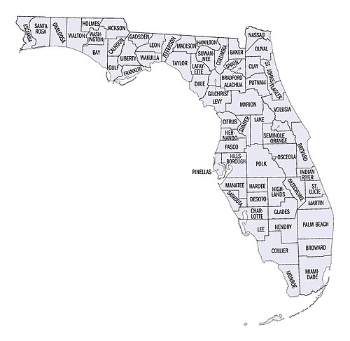
Image source: upload.wikimedia.org
Using GIS Data for Custom Mapping
Professionals often require more than just a visual aid. By utilizing datasets from the FDOT ArcGIS portal , users can overlay county boundaries with other critical layers, such as traffic patterns, flood zones, or school districts. This level of detail is essential for urban planning and commercial real estate development.
Interactive maps also solve the "city-county" confusion. By clicking on a specific county, users can immediately identify the county seat and the major incorporated cities within those borders. This is particularly useful in large counties like Miami-Dade or Broward, where dozens of distinct municipalities exist within a single county boundary.
Download Official Florida County Map PDFs for Printing
Despite the rise of digital tools, high-quality printable maps remain a staple for classrooms, government offices, and logistics hubs. The Florida Department of Transportation (FDOT) maintains a library of official general highway maps that are widely considered a top choice for accuracy and detail.
Available Map Formats
- Educational Outline Maps: These simplified versions are excellent for student testing and geographic drills, focusing solely on boundaries and names.
- Detailed Highway Maps: These include major interstate systems (I-95, I-75, I-4), state roads, and significant local arteries, making them a primary resource for route planning.
- City-County Boundary Maps: These highlight the distinction between incorporated city limits and unincorporated county land, which is vital for tax and jurisdictional purposes.
When downloading a Florida map PDF , ensure you are using the most recent version. Infrastructure projects and new city incorporations can alter the visual landscape, though county lines themselves rarely change in the modern era.
Which Florida County Is the Largest?
There is often confusion regarding which county holds the title of "largest" in Florida. The answer depends entirely on whether you are measuring total area (which includes water) or land area . This distinction is critical for researchers analyzing population density or agricultural output.
Largest by Total Area
Palm Beach County ranks as the largest by total area, covering approximately 2,383 square miles. A significant portion of this area includes water, specifically parts of Lake Okeechobee and coastal Atlantic waters.
Largest by Land Area
Collier County stands out as the largest by land area, encompassing 1,998 square miles. Much of this land is protected within the Big Cypress National Preserve and the Everglades, limiting urban development but providing massive ecological value.
Top 5 Largest Florida Counties by Land Area
| Rank | County | Land Area (Sq Mi) | Primary Feature |
|---|---|---|---|
| 1 | Collier | 1,998 | Everglades / Big Cypress |
| 2 | Palm Beach | 1,970 | Agriculture / Coastal Urban |
| 3 | Miami-Dade | 1,898 | Urban Core / Everglades |
| 4 | Polk | 1,798 | Citrus / Phosphate Mining |
| 5 | Marion | 1,579 | Horse Capital / Springs |
Understanding Florida’s Overlapping Districts and Jurisdictions
A standard Florida county map only tells part of the story. Depending on your industry, you may need to navigate "districts" that group counties together for administrative purposes. These boundaries often overlap in ways that can be confusing to the uninitiated.
Transportation and Infrastructure (FDOT)
The Florida Department of Transportation divides the 67 counties into seven distinct districts, plus the Florida Turnpike Enterprise. For example, District 1 covers Southwest Florida (including Lee and Collier), while District 6 is dedicated solely to Miami-Dade and Monroe counties. Understanding these groupings is essential for anyone working in civil engineering or state-funded construction.
Educational and Film Jurisdictions
Education officials use Educational Negotiator Areas to coordinate school board policies across six regions. Similarly, the film industry utilizes a network of over 60 local film offices, as detailed by Film In Florida , to manage permits and location scouting. These jurisdictions often follow county lines but operate under different regional headers.
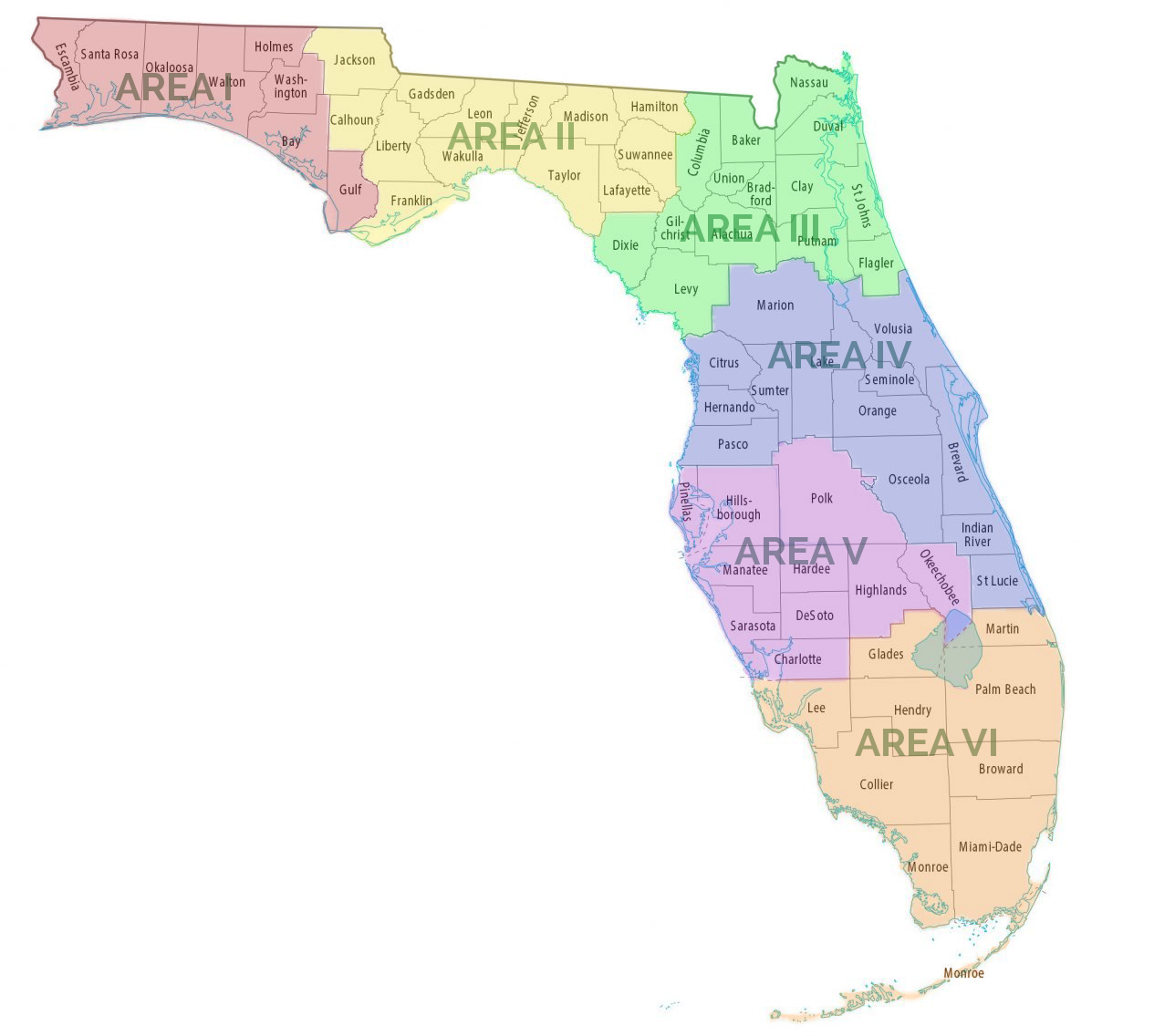
Image source: Florida Educational Negotiators
How to Map ZIP Codes to Florida Counties
A common challenge for business analysts is converting a list of ZIP codes into a county-based report. Because ZIP codes are designed for mail delivery by the USPS, they do not always align perfectly with political boundaries. Some ZIP codes may even straddle two different counties.
Technical Workflow for ZIP-to-County Mapping
- Acquire a Crosswalk File: Use a reliable source like RandyMajors to find tools that map ZIP codes to their primary county.
- Identify Split ZIP Codes: Be aware that roughly 10-15% of ZIP codes in high-growth areas like Central Florida may cross county lines. In these cases, data is usually assigned to the county where the majority of the population resides.
- Import to GIS Software: For advanced heatmapping, import your ZIP data into Google Earth or ArcGIS using a Florida GeoJSON file. This allows you to visualize sales, health data, or demographic trends across county borders.
This process is particularly useful for public health officials. For instance, the Florida Department of Agriculture (FDACS) uses county-level mapping to track equine diseases, allowing veterinarians to see exactly where outbreaks are occurring relative to county boundaries.
The History of Florida’s County Borders from 1821 to Today
Florida’s geographic history is a story of fragmentation. When Spain ceded Florida to the United States in 1821, the territory was divided into just two massive counties: Escambia in the west and St. Johns in the east. The Suwannee River served as the dividing line between these two administrative giants.
According to archives at the University of South Florida , the evolution of these borders was driven by the need for residents to be within a day's travel of their county seat. As transportation improved, the pressure to create smaller, more accessible counties diminished, leading to the stable map we recognize today.
Florida County Data and Demographics at a Glance
For those conducting demographic research, having a sortable reference for population and land area is essential. The following table highlights the extremes of Florida's geography, comparing the most populous urban centers with the rural interior.
| County | County Seat | 2026 Est. Population | Land Area (Sq Mi) | FIPS Code |
|---|---|---|---|---|
| Miami-Dade | Miami | 2,802,000+ | 1,898 | 12086 |
| Broward | Fort Lauderdale | 1,960,000+ | 1,210 | 12011 |
| Hillsborough | Tampa | 1,520,000+ | 1,020 | 12057 |
| Orange | Orlando | 1,480,000+ | 903 | 12095 |
| Liberty | Bristol | ~8,000 | 836 | 12077 |
| Union | Lake Butler | ~16,000 | 240 | 12125 |
Miami-Dade remains the most populous county by a significant margin, while Liberty County in the Panhandle continues to be the least populous. This disparity highlights the "Two Floridas"—one a bustling, high-density coastal corridor and the other a quiet, agricultural interior.
Why Some Florida County Seats Are Not Cities
A common point of confusion for those using a Florida counties with cities map is the status of the county seat. In most states, the county seat is a major incorporated city. However, in Florida, several county seats are actually "unincorporated communities" or "census-designated places" (CDPs).
For example, Crawfordville is the county seat of Wakulla County, yet it is not an incorporated city. It has no mayor or city council; instead, it is managed directly by the county commission. Similarly, East Naples serves as the seat for Collier County, despite being an unincorporated area adjacent to the city of Naples. This distinction is important for legal filings and when determining which law enforcement agency has primary jurisdiction.
Frequently Asked Questions
Final Takeaways for Navigating Florida’s Counties
Understanding the Florida county map is essential for anyone interacting with the state's administrative, economic, or historical landscape. Here are the key points to remember:
- 67 Counties: Florida has a fixed number of 67 counties, with the newest (Gilchrist) established in 1925.
- Area Distinctions: Distinguish between Total Area (Palm Beach) and Land Area (Collier) for accurate geographic research.
- Administrative Layers: Be aware of overlapping FDOT, Education, and Film districts that may group counties differently.
- County Seats: Not all county seats are incorporated cities; some, like Crawfordville, are managed directly by the county.
- Official Resources: Always use FDOT or USF archives for the most accurate highway and historical mapping data.
- ZIP Mapping: Use specialized crosswalk tools to account for ZIP codes that straddle county lines.
For your next project, start by downloading a high-resolution PDF from the FDOT portal to ensure you are working with the most current boundary data available.