Home
Where Are the Major Cities and Towns Located on a Map of Arizona?
Arizona is organized into 15 counties containing 92 incorporated municipalities as of late 2026. The state's urban landscape is dominated by the "Sun Corridor," a mega-region stretching from the Phoenix Metropolitan Area to Tucson. While Phoenix serves as the primary economic and administrative hub, the state features diverse regional centers ranging from the high-elevation mountain cities of Flagstaff and Show Low to the rapidly expanding desert communities of the West Valley.
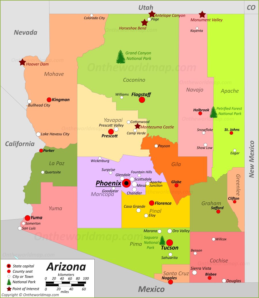
Image source: Ontheworldmap.com
Navigating a map of Arizona cities requires an understanding of the state's unique topography and administrative divisions. Unlike many eastern states, Arizona's population is highly concentrated in a few massive urban clusters, leaving vast stretches of the state as protected federal land, tribal nations, or rugged wilderness. To accurately locate a specific town or city, one must first identify which of the three primary geographic regions it occupies: the Basin and Range (desert south), the Transition Zone (central highlands), or the Colorado Plateau (high northern desert).
How to Read the Map of Arizona Cities and Counties
When viewing a map of the Grand Canyon State, the first thing most observers notice is the sheer size of the counties. Arizona has some of the largest counties in the United States by land area, which significantly impacts how local government and mapping services are managed. Understanding these boundaries is essential for everything from property research to planning a cross-state road trip.
Understanding the 15 Counties of the Grand Canyon State
Arizona's 15 counties serve as the primary administrative arm of the state government. Maricopa County is the most populous, housing over 60% of the state's residents, while Coconino County is the largest by land area, encompassing the Grand Canyon and the San Francisco Peaks. According to GISGeography , these counties are often anchored by a "county seat," which acts as the central hub for legal and governmental records.
- Maricopa County: The central hub including Phoenix, Mesa, and Scottsdale.
- Pima County: The southern anchor, home to Tucson and the Saguaro National Park.
- Coconino County: The northern giant, containing Flagstaff and the Grand Canyon.
- Yavapai County: The central highlands, featuring Prescott and Sedona.
- Pinal County: The rapid-growth corridor between Phoenix and Tucson.
Navigating the Major Interstate and Highway Corridors
The skeleton of any Arizona city map is its interstate system. Because of the state's vast distances, these routes are the lifelines connecting urban centers. Interstate 10 (I-10) is the primary east-west artery, connecting California to New Mexico through Phoenix and Tucson. Interstate 17 (I-17) is the critical north-south link that climbs nearly 6,000 feet in elevation as it travels from the desert heat of Phoenix to the alpine forests of Flagstaff.
Other vital routes include Interstate 40 (I-40) , which follows the historic path of Route 66 across Northern Arizona, and Interstate 8 (I-8) , which connects the agricultural hub of Yuma to the rest of the state. Travelers should note that while these routes are well-maintained, rural stretches can have limited services for 50 miles or more, a fact often highlighted by Geology.com in their road infrastructure analysis.
Where Tribal Lands and Reservations Fit on the Map
A significant portion of Arizona's map—approximately 27%—is comprised of tribal lands. The Navajo Nation in the northeast is the largest reservation in the country, covering roughly 25,000 square miles. These lands are sovereign nations with their own laws and mapping designations. When navigating these areas, it is important to recognize that many roads may be unpaved and municipal boundaries function differently than in incorporated Arizona cities.
Which Cities Make Up the Phoenix Metropolitan Area?
The Phoenix Metropolitan Area, often called the "Valley of the Sun," is one of the fastest-growing regions in the United States. As of 2026, the metro area has expanded so significantly that it now effectively merges with neighboring Pinal County. Mapping this region requires distinguishing between the "East Valley" and the "West Valley," each of which has a distinct economic and cultural identity.
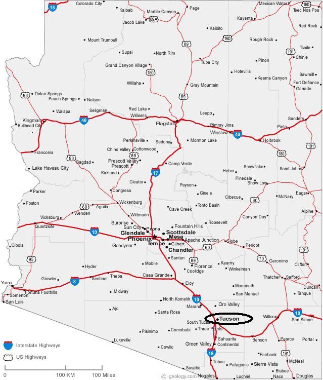
Image source: Premier Tucson Homes
The Core Hubs of the Valley of the Sun
The "Big Five" cities—Phoenix, Mesa, Chandler, Scottsdale, and Glendale—form the core of the metro area. Phoenix remains the anchor, but Mesa has grown to a size that rivals many major U.S. state capitals. Scottsdale is widely regarded as a top choice for tourism and luxury living, while Chandler has established itself as a significant advancement in the state's technology sector, often referred to as the "Silicon Desert."
The Rapid Growth of the West Valley and East Valley
In recent years, the map of the West Valley has been redrawn by the explosive growth of cities like Buckeye and Goodyear . Buckeye, in particular, has consistently ranked among the top fastest-growing cities in the nation. On the opposite side, the East Valley continues to push eastward into the Superstition Mountains, with Apache Junction and Queen Creek seeing similar surges in residential development. According to Wikipedia's municipal data , these areas have seen double-digit percentage increases in population over the last decade.
Why Gilbert Remains a Town Despite Its Massive Population
One of the most interesting anomalies on the Arizona map is the Town of Gilbert . With a population exceeding 270,000, Gilbert is larger than many cities, yet it retains the "Town" designation. This is a deliberate choice by the community to maintain a specific governance structure and "small-town feel," despite its suburban reality. It stands as the largest incorporated town in the United States, proving that municipal status in Arizona is as much about community identity as it is about population count.
What Is the Difference Between a City and a Town in Arizona?
For those researching Arizona municipal boundaries, the distinction between a "City" and a "Town" is more than just semantic. It is a legal status defined by the Arizona Revised Statutes. While both are incorporated municipalities, they operate under slightly different sets of rules regarding their organization and powers.
The Legal Threshold for Municipal Incorporation
To incorporate as a town in Arizona, a community typically needs a minimum population of 1,500 residents. However, if the community is located within three miles of a National Park or Monument, that threshold drops to just 500 residents. To transition from a town to a city, a municipality must reach a population of 3,000. This process is not automatic; the residents must vote to change their status, which is why large communities like Gilbert or Sahuarita may remain towns indefinitely.
Powers and Responsibilities of Arizona Cities vs Towns
The primary difference lies in the structure of government. Cities have the option to adopt a "Common Council" form of government or a "Charter" government, which allows for more local autonomy in how they manage utilities, construction, and local taxes. Towns generally follow a more standardized state-prescribed format. According to the Arizona League of Cities and Towns Explorer , cities often have broader authority to regulate public utilities and municipal services compared to their town counterparts.
Spotlight on San Tan Valley as the Newest Incorporated Town
A major update to the Arizona map occurred in September 2025 , when San Tan Valley officially incorporated as a town. Previously one of the largest unincorporated census-designated places (CDPs) in the country, San Tan Valley's transition to a town was a significant step forward for the residents of Pinal County. This change means the community now has its own local government, police services, and zoning authority, moving away from total reliance on county-level administration.
| Feature | Town Designation | City Designation |
|---|---|---|
| Min. Population | 1,500 (500 near parks) | 3,000 |
| Governance | Common Council | Charter or Common Council |
| Utility Regulation | Standard State Rules | Expanded Local Authority |
| Example | Gilbert, Sahuarita | Phoenix, Tucson |
Where Are the Top-Rated Mountain Cities Located in Arizona?
While the desert cities get the most attention, Arizona's mountain cities offer a completely different geographic experience. These communities are located in the "Transition Zone" and the "Colorado Plateau," where elevations range from 4,500 to over 7,000 feet. Mapping these cities is essential for those looking to escape the summer heat or enjoy winter sports.
High Elevation Living in Flagstaff and Williams
Flagstaff is the crown jewel of Northern Arizona. Situated at 6,909 feet at the base of the San Francisco Peaks, it is one of the highest cities of its size in the United States. Nearby Williams, known as the "Gateway to the Grand Canyon," maintains a historic atmosphere centered around the Grand Canyon Railway. These cities are frequently visited for their proximity to the Coconino National Forest and are highlighted by VisitArizona as essential stops for high-altitude recreation.
The Central Highlands of Prescott and Payson
Located in the heart of the state, Prescott and Payson offer a "best of both worlds" climate. Prescott, the former territorial capital, is famous for its "Whiskey Row" and Courthouse Plaza. Payson, often called the "Heart of Arizona," sits just below the Mogollon Rim, a massive geological escarpment that defines the central part of the state map. These cities are top choices for retirees and outdoor enthusiasts who prefer four distinct seasons without the extreme snow of the higher plateaus.
The White Mountains and Show Low Region
On the eastern edge of the Arizona map lies the White Mountains. Cities like Show Low and Pinetop-Lakeside are surrounded by the largest stand of Ponderosa Pines in the world. This region is a significant advancement for Arizona's tourism industry, offering fishing, hiking, and skiing at Sunrise Park Resort. Mapping this area requires attention to the winding state routes (like SR 260 and SR 77) that traverse the rugged terrain.
How to Use Professional GIS Maps for Arizona Property Research
For researchers, developers, and new residents, a standard road map isn't enough. Professional Geographic Information Systems (GIS) portals provide the most accurate and detailed data available. These tools allow users to see property lines, zoning districts, floodplains, and even underground utility easements.
Accessing Maricopa and Pima County GIS Portals
Maricopa and Pima counties maintain exceptionally strong GIS portals that are open to the public. The Maricopa County Assessor’s Parcel Viewer is a top-tier resource for identifying property ownership and tax history. Similarly, the Pima County GIS Main Map offers layers for historical aerial photography, which can show how a city like Tucson has evolved over decades. These portals are notably innovative in their ability to overlay complex data sets onto a simple map interface.
Troubleshooting Digital Maps and GPX Files for Rural Travel
While digital mapping apps are generally reliable in urban areas, they can lead to "point-to-point connection disasters" in rural Arizona. Community feedback from groups like the Arizona Peace Trail users suggests that standard GPS apps often struggle with forest service roads and desert tracks. For off-road navigation, it is highly recommended to use dedicated GPX files and offline mapping tools. Always verify that your digital map accounts for seasonal road closures, especially in the high country where snow can block routes from November through April.
"In the Arizona backcountry, a digital map is a tool, but a paper map is a safety device. Never rely solely on a cellular connection when navigating the Transition Zone or the Navajo Nation."
Complete List of Arizona Municipalities by Population and County
The following table provides a snapshot of the major incorporated areas in Arizona. Population figures are based on the most recent 2026 estimates, reflecting the continued growth in the Sun Corridor and the incorporation of new areas like San Tan Valley.
| City/Town Name | County | Estimated Population (2026) | Type |
|---|---|---|---|
| Phoenix | Maricopa | 1,685,000 | City |
| Tucson | Pima | 552,000 | City |
| Mesa | Maricopa | 525,000 | City |
| Chandler | Maricopa | 285,000 | City |
| Gilbert | Maricopa | 278,000 | Town |
| Glendale | Maricopa | 255,000 | City |
| Scottsdale | Maricopa | 250,000 | City |
| Peoria | Maricopa/Yavapai | 202,000 | City |
| San Tan Valley | Pinal | 115,000 | Town (Inc. 2025) |
| Flagstaff | Coconino | 78,000 | City |
| Winkelman | Gila/Pinal | 290 | Town |
Frequently Asked Questions
What is the oldest city in Arizona?
Tucson is widely regarded as the oldest incorporated city in Arizona, having been officially incorporated in 1877. However, the area has been inhabited for thousands of years by indigenous peoples, and the Spanish established the Presidio San Agustín del Tucsón in 1775. Its long history is reflected in the city's unique blend of Native American, Spanish, Mexican, and Anglo-American cultures, which you can see on historical maps of the downtown area.
What is the smallest municipality in Arizona?
As of the most recent data, Winkelman remains the smallest incorporated municipality in Arizona, with a population typically hovering around 300 residents. Located at the confluence of the Gila and San Pedro Rivers, it serves as a historic mining and ranching community. Despite its small size, it maintains its own municipal government, providing a fascinating example of how Arizona's incorporation laws allow very small communities to maintain local control.
Which Arizona cities are closest to the Grand Canyon?
The closest incorporated municipalities to the Grand Canyon National Park are Tusayan, Williams, and Flagstaff. Tusayan is located directly at the South Rim entrance and serves primarily as a resort and service hub for park visitors. Williams is about 60 miles south and is a popular choice for those taking the Grand Canyon Railway. Flagstaff, about 80 miles away, is the largest regional city and offers the most extensive amenities for travelers heading to the canyon.
How many cities are in Arizona in 2026?
In 2026, there are 92 incorporated cities and towns in Arizona. This number increased recently with the incorporation of San Tan Valley in late 2025. While there are hundreds of other named communities, census-designated places (CDPs), and neighborhoods, only these 92 have their own local municipal governments. The rest are governed directly by the county in which they are located.
Is San Tan Valley a city or a town?
San Tan Valley is officially incorporated as a town. Following a successful vote in 2025, the community transitioned from an unincorporated area of Pinal County to a self-governing town. This status allows the community to manage its own local services, such as parks and recreation, while still maintaining the "Town" designation that many Arizona communities prefer for its specific governance structure.
Final Takeaways for Navigating Arizona Cities
Understanding the map of Arizona cities is essential for navigating the state's diverse landscapes and growing urban centers. Whether you are a resident, a researcher, or a traveler, keep these key points in mind:
- Identify the County: Start by locating the city within one of the 15 counties to understand the administrative framework.
- Distinguish City vs. Town: Remember that "Town" status is a legal choice and does not necessarily indicate a small population, as seen with Gilbert.
- Watch the Elevation: Arizona's map is three-dimensional; traveling from Phoenix to Flagstaff involves a massive 6,000-foot climb.
- Use GIS Resources: For property or technical research, rely on county GIS portals rather than standard consumer mapping apps.
- Respect Tribal Sovereignty: Recognize that tribal lands have their own boundaries and regulations that differ from state-incorporated cities.
- Stay Current: The map is always changing, with San Tan Valley being the most recent major addition to the list of incorporated towns.
For the most accurate results, always cross-reference digital maps with official state and county resources to ensure you have the most recent municipal boundary data.