Home
What Are the Main Bodies of Water on Earth and Why Do They Matter?
Water covers approximately 71% of Earth's surface , with the vast majority (about 97%) held in five massive oceans. The remaining water is distributed among seas, lakes, rivers, and glaciers. While oceans are the primary drivers of global climate, freshwater bodies like rivers and lakes provide the essential resources required for human civilization and terrestrial life.
Earth is often described as the "Blue Planet," a title earned by the staggering volume of water that defines its geography. From the crushing depths of the Mariana Trench to the winding path of the Nile, these water bodies are not isolated features but part of a highly interconnected global system. Understanding the classification and function of these waters is essential for geography, environmental science, and practical activities like maritime trade and recreation.
According to data from the WorldAtlas , the distribution of water is heavily skewed toward saltwater environments. While we often focus on the rivers and lakes that sustain our cities, they represent only a tiny fraction of the planet's total water volume. This article explores the nuances of these water bodies, addressing common misconceptions and providing a technical framework for their classification.
How Many Oceans Are There Really?
For decades, students were taught that there were four oceans: the Pacific, Atlantic, Indian, and Arctic. However, modern geography recognizes a fifth major body. The Southern Ocean (also known as the Antarctic Ocean) was officially recognized by the International Hydrographic Organization and other major bodies around the year 2000. This recognition resolved a long-standing debate about whether the waters surrounding Antarctica were merely extensions of the Atlantic and Pacific or a distinct system defined by the Antarctic Circumpolar Current.
Pacific Ocean
The largest and deepest ocean, covering more area than all of Earth's landmasses combined. It is home to the Ring of Fire and the deepest point on Earth.
Atlantic Ocean
The second-largest ocean, acting as a primary corridor for global trade. It is known for the Mid-Atlantic Ridge and its high salinity levels.
Indian Ocean
The third-largest ocean, bounded by Asia, Africa, and Australia. It is notable for its warm tropical waters and significant monsoon patterns.
Southern Ocean
Encircling Antarctica, this ocean is defined by cold, nutrient-rich waters and the strongest currents on the planet.
Arctic Ocean
The smallest and shallowest ocean, mostly covered by sea ice. It plays a critical role in regulating global climate and ocean circulation.
The concept of the "Seven Seas" is a historical and cultural framework rather than a modern scientific one. In contemporary terms, the Seven Seas are often reconciled as the North Atlantic, South Atlantic, North Pacific, South Pacific, Indian, Southern, and Arctic Oceans. This division highlights how cultural perspectives on geography evolve as our scientific understanding of ocean currents and boundaries improves.
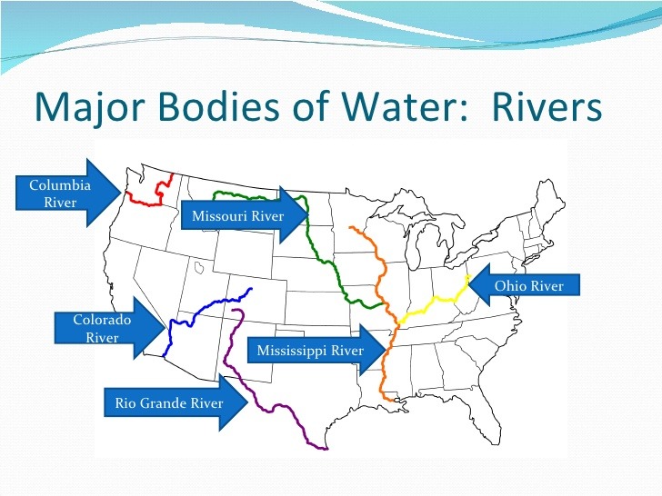
Image source: Quizlet
What Makes a Sea Different From an Ocean?
While the terms are often used interchangeably in casual conversation, seas and oceans have distinct geographical definitions. A sea is typically defined as a smaller body of saltwater that is partially enclosed by land. Seas are often found where the ocean meets the continents, such as the Mediterranean Sea or the Caribbean Sea. Because they are closer to land, seas tend to have different salinity levels and temperatures compared to the open ocean.
One common point of confusion is the ranking of the world's largest seas. While many older texts cite the South China Sea as the largest, modern measurements often place the Philippine Sea at the top of the list by surface area, covering approximately 2.1 million square miles. These rankings can shift depending on how researchers define the boundaries between the sea and the adjacent ocean.
The Caspian Sea and the Inland Sea Debate
The Caspian Sea presents a unique classification challenge. It is the world's largest inland body of water, but is it a lake or a sea? Geologically, it has a basin composed of oceanic crust, and its water is brackish (salty, but less so than the ocean). However, because it is entirely landlocked and has no natural outlet to the world's oceans, many geographers classify it as the world's largest lake. This distinction is not just academic; it has significant implications for international maritime law and the rights to the vast oil and gas reserves found beneath its surface.
Where Does a River End and an Ocean Begin?
One of the most complex problems in hydrology is defining the "Transition Zone." This is the area where a freshwater river meets the saltwater of the ocean. This zone is rarely a sharp line; instead, it is a gradient where the two types of water mix. This area is technically known as an estuary .
Defining Estuaries and Transition Zones
According to the US EPA , estuaries are semi-enclosed coastal bodies of water where freshwater from rivers and streams meets and mixes with saltwater from the ocean. These areas are among the most biologically productive ecosystems on the planet, serving as "nurseries" for many species of fish and shellfish. However, they are also difficult to manage because they fall under multiple jurisdictions—river authorities, coastal management agencies, and international maritime bodies.
The "Transition Zone" problem also involves the physical behavior of water. Because saltwater is denser than freshwater, it often slides underneath the freshwater in a phenomenon known as a "salt wedge." This means that at the mouth of a river, the surface water might be fresh enough to drink, while the water at the bottom is nearly as salty as the sea. This stratification affects everything from sediment transport to the types of plants that can grow along the shoreline.
How to Classify Other Major Waterway Types
Beyond oceans, seas, and rivers, there are several other types of water bodies that play vital roles in geography and navigation. These are often defined by their shape, size, and relationship to the surrounding land.
- Gulf
- A large portion of the ocean that penetrates the land. The Gulf of Mexico is a prime example, being the largest gulf in the world.
- Bay
- Similar to a gulf but generally smaller and with a wider opening to the sea. Hudson Bay is a notable exception, being larger than many gulfs.
- Strait
- A narrow passage of water connecting two larger bodies of water, such as the Strait of Gibraltar.
- Channel
- A wider version of a strait, often used for navigation between two landmasses, like the English Channel.
- Lakes and Endorheic Basins
- Landlocked bodies of water. Endorheic basins are unique because they have no outlet; water only leaves through evaporation, often leading to high salt concentrations (e.g., the Great Salt Lake).
Comparing Gulfs and Bays
The distinction between a gulf and a bay is often subjective and based on historical naming conventions. Generally, a gulf is considered to be more deeply recessed into the land and larger in scale. However, the Hudson Bay in Canada covers a larger area than the Gulf of Mexico, proving that these definitions are not always consistent. In modern geography, the focus is often more on the "fetch" (the distance wind can travel over open water) and the depth of the basin rather than the specific label.
| Water Body Type | Salinity | Flow Type | Primary Example |
|---|---|---|---|
| Ocean | Saltwater | Global Currents | Pacific Ocean |
| Sea | Saltwater/Brackish | Tidal/Currents | Mediterranean Sea |
| River | Freshwater | Unidirectional Flow | Amazon River |
| Lake | Fresh/Salt/Brackish | Still/Internal Flow | Lake Superior |
| Estuary | Brackish | Mixed/Tidal | Chesapeake Bay |
Why Some Rivers Flow North and Other Common Myths
A persistent myth in geography is that rivers only flow south, likely due to the visual orientation of maps where "down" is south. In reality, water is governed by gravity and always flows from higher elevation to lower elevation, regardless of compass direction. While many major rivers in North America flow south toward the Gulf of Mexico, there are numerous significant rivers that flow north.
The Nile River is the most famous example of a north-flowing river, traveling from the highlands of East Africa to the Mediterranean Sea. Other major north-flowing rivers include the Ob and Yenisey in Russia, and the Mackenzie River in Canada. Understanding the anatomy of a river—from its source (headwaters) to its meanders and finally its delta—is crucial for understanding how water shapes the landscape over millennia.
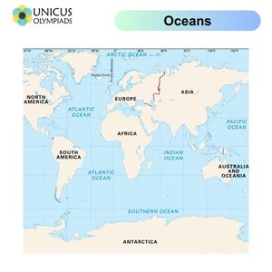
Image source: Unicus Olympiads
How to Read Different Water Bodies for Boating and Fishing
For those who interact with water bodies recreationally or professionally, the physical characteristics of the water dictate strategy and safety. Boating in a freshwater lake is a fundamentally different experience than navigating a tidal river or the open ocean. According to experts at Hi-Tide , the most critical factor for boaters is understanding the specific maintenance and safety requirements of their environment.
- Saltwater Maintenance: Salt is highly corrosive. Engines used in saltwater must be flushed with freshwater after every use to prevent internal damage. Zinc anodes are also used to protect metal parts from galvanic corrosion.
- Fighting the Current: In rivers, boaters must account for the speed of the current, which can change rapidly based on rainfall or dam releases. Navigating upstream requires more fuel and power than moving with the flow.
- Reading the Shoreline: Anglers often "read" the water by looking for structures like points, drop-offs, and submerged vegetation. In lakes, fish often congregate near these features for protection and food.
- Safety Hazards: Freshwater lakes can freeze in winter, creating hazards for docks and hulls. Conversely, the open ocean presents the risk of large swells and unpredictable weather patterns that are rarely seen on inland waters.
Why Water Geography Dictates Global Power
The location and navigability of water bodies have historically determined the rise and fall of empires. The concept of a "Warm Water Port"—a port that does not freeze in the winter—has been a driving force in Russian foreign policy for centuries. Without access to year-round shipping lanes, a nation's ability to trade and project naval power is severely limited.
Similarly, navigable internal waterways like the Mississippi River system have provided the United States with a significant economic advantage. These rivers allow for the low-cost transport of agricultural and industrial goods from the interior of the continent to global markets. As noted in studies from Study.com , the control of "choke points" like the Suez Canal or the Strait of Hormuz remains a central pillar of modern geopolitical strategy.
The Modern Crisis of Shrinking Main Bodies
While we often view the world's main bodies of water as permanent fixtures, human impact and climate change are actively altering their boundaries. The most dramatic example is the Aral Sea in Central Asia. Once the fourth-largest lake in the world, it has shrunk to a fraction of its original size due to Soviet-era irrigation projects that diverted the rivers feeding it. This has resulted in an ecological disaster, leaving behind a salty desert and destroying local fishing industries.
Water scarcity is not limited to disappearing lakes. According to the World Wildlife Fund (WWF) , approximately 1.1 billion people worldwide lack access to water, and 2.7 billion find water scarce for at least one month of the year. Agriculture alone consumes about 70% of the world’s accessible freshwater, often at rates faster than nature can replenish it. This highlights the need for "systems thinking" in water conservation—recognizing that what happens in a small upstream river eventually impacts the health of the entire ocean system.
Global Water Rankings by the Numbers
To understand the scale of these bodies, it is helpful to look at the data. These rankings provide a sense of the sheer volume and depth of the water that covers our planet. Note that measurements for river lengths can vary; for example, while the Nile is traditionally cited as the longest, some researchers argue the Amazon is longer when measured from its most distant source.
- Largest Sea by Surface Area: Philippine Sea (~2,100,000 sq miles)
- Deepest Point in the Ocean: Challenger Deep, Mariana Trench (~10,935 meters)
- Deepest Lake: Lake Baikal, Russia (1,642 meters)
- Highest Navigable Lake: Lake Titicaca, Andes Mountains (3,812 meters elevation)
- Largest Drainage Basin: Amazon River (covers nearly 40% of South America)
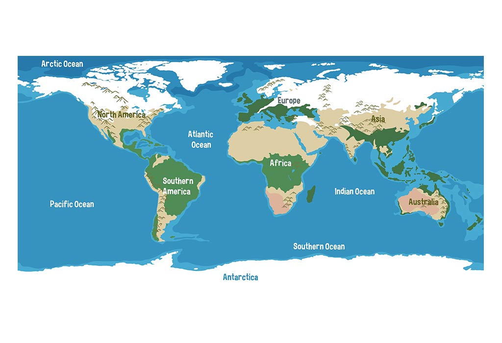
Image source: FirstCry
Frequently Asked Questions
1 What are the 8 major bodies of water?
While there is no single official list of "8 major bodies," this often refers to a common educational grouping that includes the 5 oceans (Pacific, Atlantic, Indian, Arctic, and Southern) plus three significant regional bodies like the Mediterranean Sea, the Caribbean Sea, and the Gulf of Mexico. These eight are frequently highlighted because of their massive size and their critical roles in global trade, climate regulation, and biodiversity.
2 What is the difference between a gulf and a bay?
The primary difference lies in size and shape. A gulf is typically a large portion of the ocean that is almost surrounded by land, often with a narrow opening. A bay is generally smaller and has a wider opening to the sea. However, these terms are often applied inconsistently; for instance, the Bay of Bengal and Hudson Bay are much larger than many bodies officially designated as gulfs. Geographers today focus more on the geological formation of the basin than the specific label.
3 Is the Caspian Sea a lake?
Technically, the Caspian Sea is the world's largest inland body of water. Because it is entirely surrounded by land and has no natural connection to the world's oceans, it is often classified as a lake. However, it possesses sea-like characteristics, including a basin of oceanic crust and brackish water. The classification is a subject of international debate because "sea" status would grant neighboring countries different maritime rights than "lake" status under international law.
4 Which river is the longest in the world?
The Nile River is traditionally recognized as the longest river in the world, stretching approximately 6,650 kilometers (4,130 miles). However, there is an ongoing scientific debate, as some researchers using satellite technology argue that the Amazon River is actually longer if its most distant source in the Peruvian Andes is included. While the Nile holds the title for length in most textbooks, the Amazon is undisputed as the largest river by water volume and drainage basin size.
5 What is brackish water?
Brackish water is water that has a salinity level between freshwater and seawater. It typically occurs in estuaries where freshwater rivers meet the salty ocean, or in certain inland seas and aquifers. Salinity is measured in parts per thousand (ppt); freshwater is usually below 0.5 ppt, while seawater is around 35 ppt. Brackish water falls anywhere in between, creating a unique chemical environment that supports specialized plant and animal life adapted to fluctuating salt levels.
Key Takeaways for Understanding Earth's Water
- Five Recognized Oceans: The Southern Ocean is the most recent addition to the global list, officially recognized for its unique current system.
- Salinity and Flow: Water bodies are classified based on their salt content (salt, fresh, or brackish) and whether the water is moving or still.
- Transition Zones: Estuaries are critical ecological areas where fresh and salt water mix, though they are geographically difficult to define.
- Gravity Over Compass: Rivers flow toward lower elevations, meaning many major rivers flow north rather than south.
- Human Impact: Major bodies like the Aral Sea are actively shrinking due to human intervention, highlighting a global water crisis.
- Geopolitical Importance: Access to navigable waterways and warm water ports remains a primary driver of national wealth and security.
To better understand the water bodies in your own region, consult local topographic maps to identify the watersheds and drainage basins that connect your local streams to the wider ocean system.