Home
How to Navigate and Explore the Bisti Badlands Without Getting Lost
The Bisti Badlands is a 45,000-acre wilderness in New Mexico with zero marked trails . To visit safely, you must use a "Navigation Stack" consisting of offline GPS maps (like Gaia GPS) and a physical compass. If electronics fail, the Wash Navigation Fail-Safe is your primary recovery method: follow the Hunter or Bisti washes downstream (West) to return to the access road. Avoid visiting within 48 hours of rain, as the bentonite clay creates impassable "20-pound feet" mud.
What Makes the Bisti Badlands a Unique Wilderness Experience
The Bisti/De-Na-Zin Wilderness, managed by the Bureau of Land Management (BLM), represents one of the most visually striking landscapes in the American Southwest. Spanning approximately 45,000 acres of high-desert terrain south of Farmington, New Mexico, this area is widely regarded as a premier destination for those seeking solitude and otherworldly geological formations. According to the BLM Official Site , the wilderness is a "trail-free" zone, meaning there are no maintained paths, signs, or facilities once you leave the parking area.
The aesthetic of the Bisti is often described as "alien" or "lunar." This is due to the erosion of interbedded sandstone, shale, mudstone, and coal. Over millions of years, these layers have been sculpted into hoodoos, spires, and balanced rocks that defy standard geological expectations. The lack of vegetation and the presence of dark, weathered coal seams (clinker) create a high-contrast environment that changes dramatically with the shifting sun.
Unlike national parks, the Bisti offers a raw experience. There are no entrance fees, no visitor centers, and no water sources. It is a place where self-reliance is not just encouraged but required for survival. The silence here is profound, broken only by the occasional wind whistling through the rock "wings" or the call of a distant raptor.
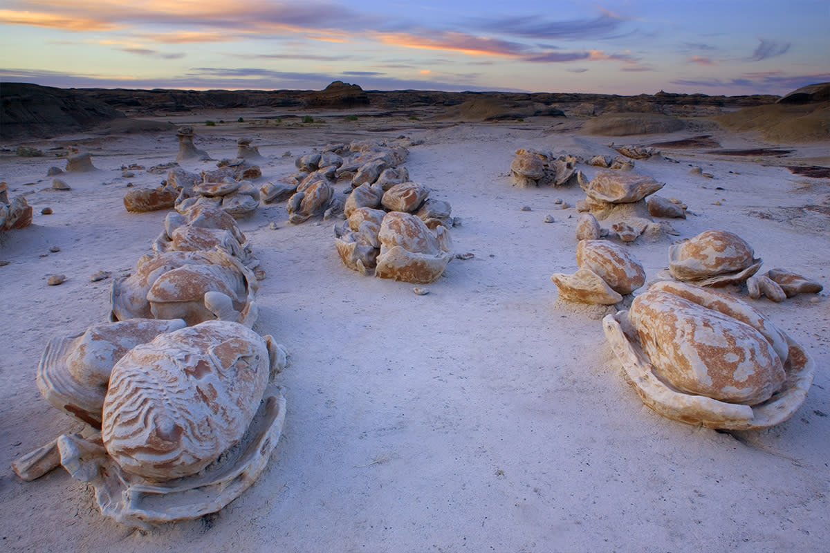
Image source: New Mexico Tourism Department
How to Prepare for a Trip to the Bisti De-Na-Zin Wilderness
Preparation for the Bisti begins with understanding its remote location. The wilderness is situated roughly 36 miles south of Farmington, NM, via Highway 371. The turnoff onto County Road 7290 leads to the main Bisti (West) trailhead. While the road is gravel and generally accessible to 2WD vehicles in dry conditions, it becomes a significant hazard during inclement weather. According to Farmington NM Tourism , visitors should always check local weather reports before committing to the drive.
Vehicle Requirements
In dry conditions, a standard sedan can reach the main parking lot. However, high-clearance vehicles are recommended for the De-Na-Zin (East) access point, which involves more rugged dirt roads. Never attempt these roads if rain is in the forecast.
Essential Gear
- 1 gallon of water per person (minimum).
- High-top hiking boots for ankle support.
- Wide-brimmed hat and SPF 50+ sunscreen.
- Satellite messaging device (Garmin InReach or Starlink-enabled phone).
There are no permits required for day use or dispersed camping for groups under 30 people. This freedom comes with the responsibility of "Leave No Trace" principles. Because the soil is extremely fragile, hikers are encouraged to walk in the sandy washes whenever possible to avoid crushing the delicate crust of the badlands. Camping is permitted, but you must be at least 1/4 mile away from water sources (which are rare) and pack out all waste, including human waste.
How to Navigate 45,000 Acres Without a Single Marked Trail
Navigation is the most significant challenge for first-time visitors. The landscape is a fractal maze of ridges and valleys that look remarkably similar from every angle. Relying on visual landmarks alone is a common pitfall that leads to hikers becoming disoriented, especially as shadows lengthen in the late afternoon.
The Modern Navigation Stack
To explore safely, you should employ a multi-layered approach to navigation. Start by downloading offline maps on an app like Gaia GPS or AllTrails. Because there is virtually no cell service in the wilderness, these maps must be saved to your device's local storage before you leave Farmington. A physical compass and a topographic map serve as the essential backup to your digital tools.
If your electronics fail or you lose your bearings, remember the "Downstream Rule." The Bisti Wilderness is drained by two primary washes: the Hunter Wash (North) and the Bisti Wash (South). Both of these washes flow West toward the access road. If you are lost, find the nearest large sandy wash and follow the direction of the water flow (downhill/West). This will eventually lead you back to the fence line and the road system [Source: TheWave.info].
Another useful technique is Peak Orientation . To the East of the wilderness, several prominent mountain peaks are visible on clear days. By keeping these peaks at your back, you are generally heading West toward the trailhead. Conversely, if you are heading into the wilderness, the peaks should be in front of you. However, be aware that as you descend into the deeper hoodoo fields, these peaks will disappear behind the ridges, making GPS essential for micro-navigation.
Where to Find the Most Iconic Formations and Hoodoos
While the entire wilderness is visually stunning, most visitors aim for a few specific clusters of formations. These are located primarily in the Bisti (West) section. It is important to manage expectations regarding scale; many formations that look massive in professional photography are actually only 5 to 10 feet tall. Including a "human for scale" in your own photos is a top-rated tip for capturing the true perspective of the landscape.
| Formation Name | Approx. Distance from Trailhead | Key Feature |
|---|---|---|
| The Cracked Eggs | 2.0 Miles | Large, oval concretions that appear to be "hatching." |
| The Bisti Wings | 2.5 Miles | Thin, horizontal sandstone plates balanced on narrow pedestals. |
| The Rock Garden | 1.5 Miles | A dense concentration of small, colorful hoodoos and spires. |
| King of Wings | 4.0 Miles (Remote) | A massive, 10-foot long horizontal spire (requires high-level navigation). |
The Cracked Eggs (Alien Hatchery)
This is the most popular destination in the Bisti. These formations are technically weathering concretions—hardened masses of sedimentary rock that have eroded at a different rate than the surrounding mudstone. The result is a field of smooth, egg-shaped rocks, many of which have "cracked" open to reveal internal layers. To reach them, hike East from the main parking lot, staying generally within or alongside the Bisti Wash for about two miles.
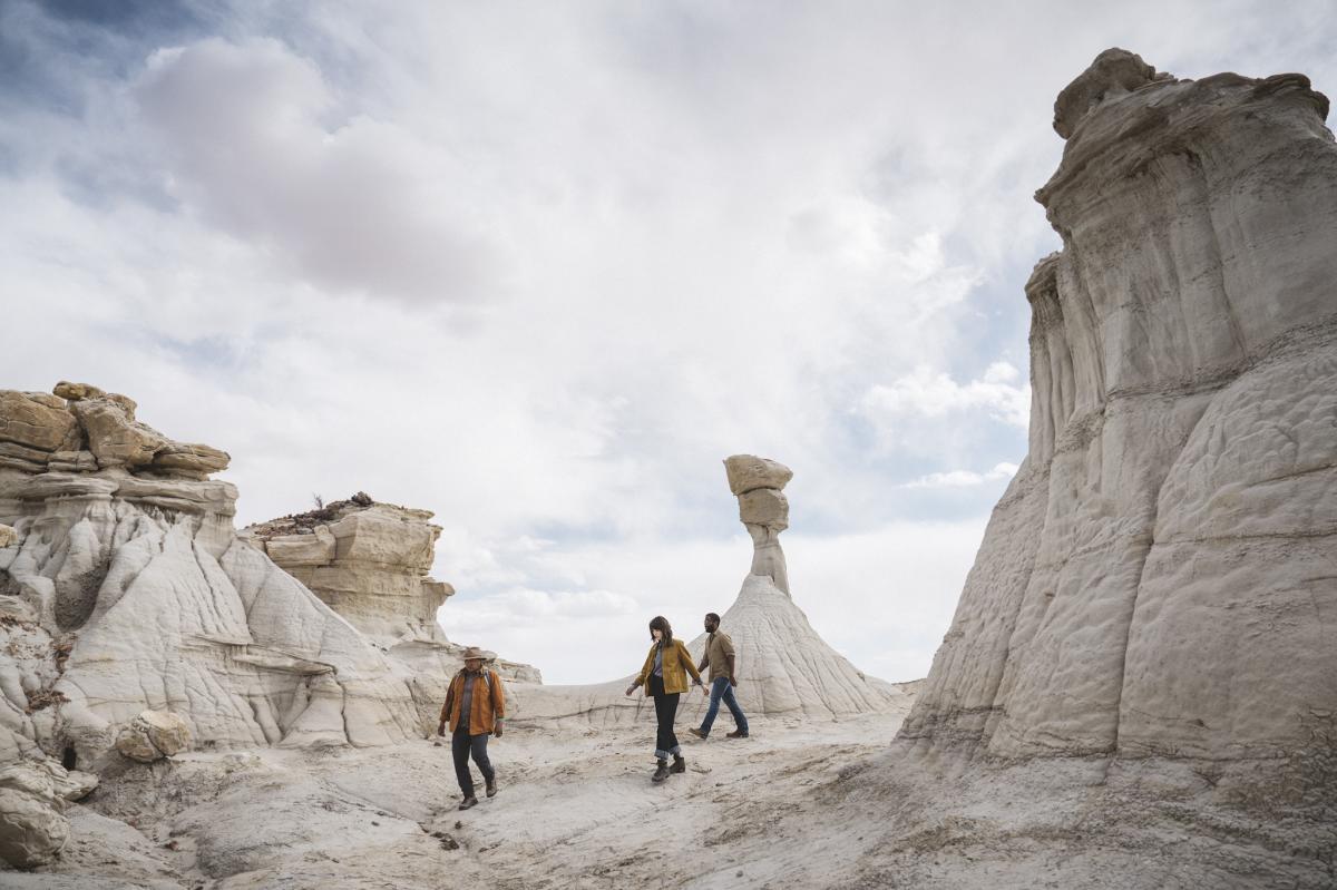
Image source: New Mexico Tourism Department
Why You Should Never Visit the Badlands During or After Rain
The geology of the Bisti is its greatest draw, but also its primary danger. The ground is composed largely of bentonite clay, a volcanic ash derivative that is highly absorbent. When dry, it is hard and popcorn-like. When wet, it undergoes a chemical transformation into a substance that is remarkably slippery and adhesive.
Walking on wet bentonite is not just difficult; it can be physically impossible. The mud sticks to the soles of your boots, accumulating in thick, heavy layers. Within a few dozen steps, each foot can weigh an additional 10 to 20 pounds. This leads to rapid exhaustion and increases the risk of ankle injuries or getting stranded far from the trailhead. If the ground feels "tacky" or soft, turn back immediately.
Beyond the physical difficulty of walking, rain creates two other major hazards. First, the washes are prone to flash flooding. Because the soil does not absorb water quickly, even a distant storm can send a wall of water through the narrow canyons. Second, the access road (CR 7290) is notorious for trapping vehicles. Even 4WD trucks can become hopelessly mired in the "gumbo" mud that forms on the road surface after a summer monsoon.
How to Capture Professional Photos of the Muted Landscape
Photographers from around the world visit the Bisti to capture its muted, pastel palette. However, the harsh desert sun can wash out the subtle colors of the mudstone, making mid-day shots look flat and uninteresting. To get the most out of your camera, you must understand the specific lighting conditions of the high desert.
Blue Hour Color Theory
While "Golden Hour" (the hour after sunrise and before sunset) is popular, many professional photographers find that the Bisti looks its best during the Blue Hour . This is the 30-minute window before the sun rises or after it sets. During this time, the sky acts as a massive softbox, casting a cool, blue-gray light that makes the reds and oranges of the "clinker" layers pop without the harsh shadows of direct sunlight. This lighting emphasizes the textures of the hoodoos and gives the landscape a truly ethereal quality.
If you are planning Milky Way or long-exposure night photography near "The Wings," be aware of a common technical hurdle. A distant light source (likely from oil and gas operations to the South) often creates a permanent red or orange glow on the horizon in long exposures. This light pollution can be difficult to remove in post-processing. To minimize this, aim your camera toward the North or Northeast for cleaner night skies [Source: Firefall Photography].
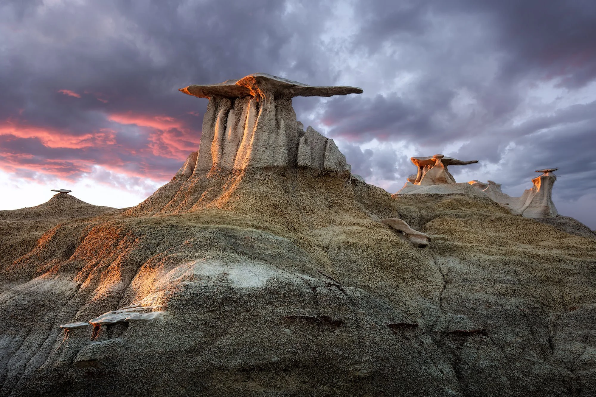
Image source: Photographers Trail Notes
What Are the Rules for Fossils and Wildlife in the Wilderness
The Bisti is a graveyard of the Cretaceous period. It is common to see petrified wood scattered across the ground, and lucky hikers may even spot fossilized bone fragments. However, the rules regarding these items are strict and federally enforced. Under the Paleontological Resources Preservation Act, it is illegal to collect, move, or damage any fossils or petrified wood within the wilderness area.
Wildlife also receives special protections. The badlands are a critical nesting habitat for Golden Eagles and Prairie Falcons. According to the New Mexico State Tourism board, approaching within 500 yards of an active nest between February 1 and July 1 is a violation of the Bald and Golden Eagle Protection Act. If you see a large nest on a high spire, maintain your distance and use a telephoto lens for viewing.
Prohibited Activities
- Drones: The use of unmanned aerial vehicles (UAVs) is strictly prohibited in all federally designated Wilderness areas.
- Bicycles: Mechanical transport, including mountain bikes, is not allowed past the wilderness boundary.
- Motorized Vehicles: All motorized travel is restricted to the designated parking areas.
Should You Visit the Bisti West or De-Na-Zin East Section
Most visitors only see the Bisti (West) section, but the De-Na-Zin (East) section offers a different, equally compelling experience. Choosing between them depends on your fitness level and what you hope to see.
Bisti (West)
Easier Navigation
This section is characterized by wide washes and concentrated hoodoo fields like the Cracked Eggs. It is generally easier to navigate because the landmarks are more distinct and the terrain is flatter.
De-Na-Zin (East)
Strenuous Hiking
The East section features deeper canyons, more colorful vistas (purples and reds), and massive logs of petrified wood. However, it requires significant climbing in and out of steep drainages and offers very little shade.
If you have only one day, the Bisti (West) section is widely considered the top choice for first-time visitors. If you are looking for total solitude and are an experienced navigator, the De-Na-Zin section provides a more rugged and lonely experience.
Key Takeaways for a Safe Visit
- Download offline maps before leaving Farmington, as cell service is non-existent in the badlands.
- Check the 48-hour weather forecast and cancel your trip if any rain is predicted to avoid the "20-pound foot" mud.
- Carry one gallon of water per person, even in the winter, as the dry air causes rapid dehydration.
- Use the Wash Navigation Fail-Safe by following Hunter or Bisti washes West (downstream) if you become disoriented.
- Respect the K-Pg boundary by leaving all fossils and petrified wood exactly where you find them.
- Plan for Blue Hour photography to capture the most vibrant pastel colors of the mudstone formations.
- Tell someone your plan and expected return time, as there is no one to call for help once you enter the wilderness.
Before you head out, double-check that your GPS device is fully charged and that you have a backup power bank in your pack.
Frequently Asked Questions